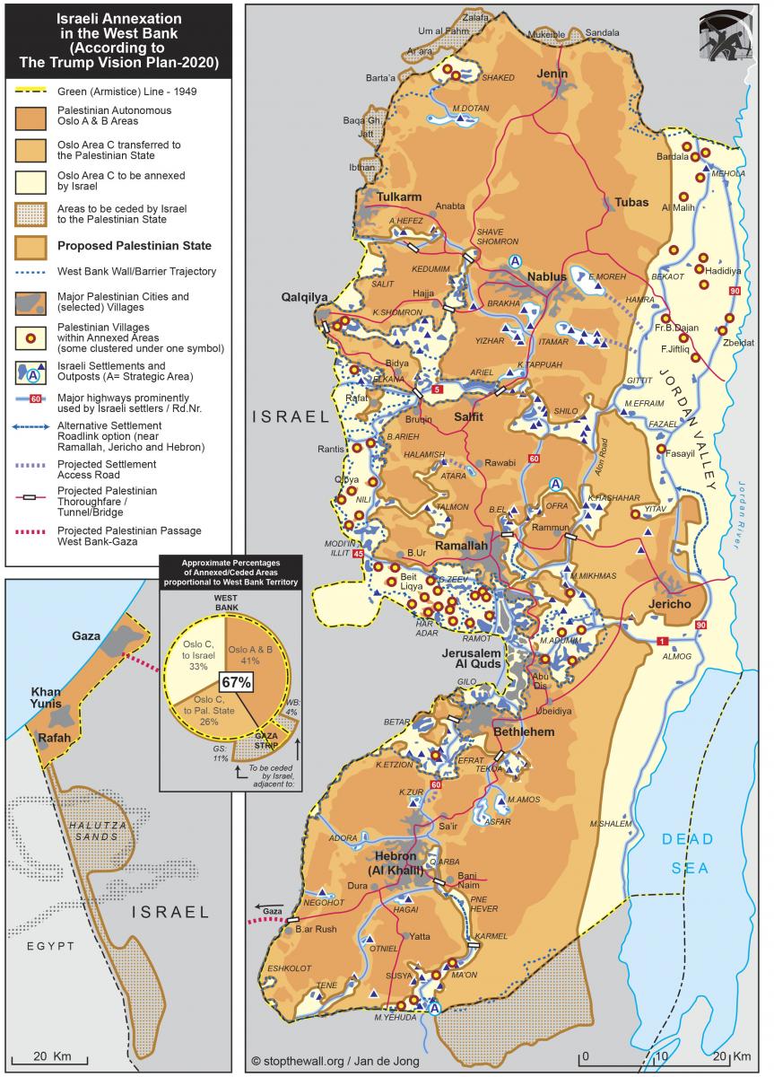
Stop the Wall released the most detailed map as of today of Trump’s Peace to Prosperity plan, including a commentary. It shows the real impact of this ‘masterplan’ – vision fully designed on the basis of Israel’s pre-existing annexation plans.
With the possible annexation of 33% of the West Bank, over 75 Palestinian villages, Bedouin and semi-Bedouin communities are to be annexed, with a total population of 118 000. They are to be annexed yet denied full citizen rights. The segregated transportation system will be expanded, most of the water resources inaccessible and agriculture impossible as most arable land will be annexed.
It becomes evident how the endless human rights violations by Israel, including the wall, the settlements, home demolitions, land confiscations, humiliating checkpoints and denial of access to water, have always been measures of de facto annexation to prepare for this masterplan.
Commentary
This map is based on the source document attached to Trump’s ‘Deal of the Century’ Plan. The lack of details in the mapsincluded in this source document does not allow one to understand the full impact of the proposed plan. It obscures crucial elements, and the oversized Tunnel-Bridge symbols conceal more than they reveal. Stop the Wall, together with Jan de Jong an expert in the geopolitics of Palestine, have produced the following map based on extensive field trips and in-depth knowledge of the reality on the ground. This map provides a detailed look at the geo-political transformations and the new realities that will be created as a result of the Israeli annexation plan.

Download the map here.
Download the commentary here.
The Bantustan reality
- The map shows that Israel’s project, fully reflected in the Trump administration’s ‘Peace to Prosperity’ plan, negates Palestinian statehood. Instead it consolidates the existence of segregated reserves and ghettos for Palestinians, one of the elements defining the crime of apartheid. Such a combination of bantustans mirrors both the structure used by the South African apartheid regime to relegate the Black population into unsustainable, segregated areas, and the confinement of Indigenous peoples to isolated reservations by US and Canadian settler colonial states, which also served as the model for the development of the bantustan system.
- It violates fundamental principles of international law such as the inadmissibility of annexation of territory by force, and the right to self-determination, and further entrenches settler colonial apartheid regime, which Israel has already imposed on the entire Palestinian people.
- The fragmentation of Palestinians visible in the map is a strategy of colonial domination: The Gaza Strip will stay isolated and the annexation of the E1 area (east of Jerusalem) will divide the northern and southern West Bank. This reinforces the annexation and demographic engineering in Jerusalem in favour of Jewish settlers.
- The map reveals the extent of more land theft. Most of the annexed areas are of strategic geopolitical importance to guarantee Israel de facto sovereignty over all of Mandate Palestine and its resources.â
De facto/de jure annexation
- Measures of de facto annexation have continued, even though Israel has after the de jure annexation of the Syrian Golan Heights and Jerusalem at the beginning of the 1980s have claimed to refrain from de jure annexation. The Israeli regime and entire settlement project de facto treat the Palestinian occupied territory as Israel’s sovereign territory. The International Court of Justice (ICJ) in its verdict confirmed the illegality of the Wall. The ICJ stated that “the Court considers the construction of the wall and its associated régime create a “fait accompli” on the ground that could become permanent, in which case, and notwithstanding the formal characterization of the wall by Israel, it would be tantamount to de facto annexation.”
-
The announced passing of a law of annexation will only heighten international existing obligations.
The apartheid Wall and roads
-
Israel’s Apartheid Wall is a fundamental part of the plan.
-
The Wall has and continues to be a measure of annexation. The proposed boundaries of annexation are overlapping with the Wall’s path which on the ground shows that the wall has already created the reality of annexation. Where the plans of annexation go further into the West Bank (see in particular the villages in Northwest Jerusalem, east of Jerusalem in the E1 area and in western Ramallah district), it is a fundamental tool to hem in larger Palestinian population centers in an isolated ‘no-man’s land’ to avoid any possibility of integration into the Israeli state because it annexes them. Eventually, the population is to be forced out of these areas.
-
The annexation plan’s transportation system, based on tunnels and bridges to keep Palestinian segregated further develops the existing apartheid road system that destroys Palestine’s historical road system, geography and encroaches on Palestinian lands. Palestinians travelling from Ramallah to Nablus will have to pass through new lengthy routes via Salfit (through an underpass) to maintain a racist settler colonial system of segregation that seeks to prevent Palestinian passage through the Shilo settlement bloc to be annexed. The same logic applies to the connections between Nablus and Qalqilya/Tulkarm, and between Hebron and destinations in the central West Bank.
-
The annexation of the area west of the settler roads n.446 (Modiin-Ariel) and n.45 (Modiin-Jerusalem) shows that Israel is determined to seize key strategic land areas and transportation lines, irrespective of the Palestinian inhabitants, despite the large Palestinian population there.
Displacement / the ongoing Nakba
-
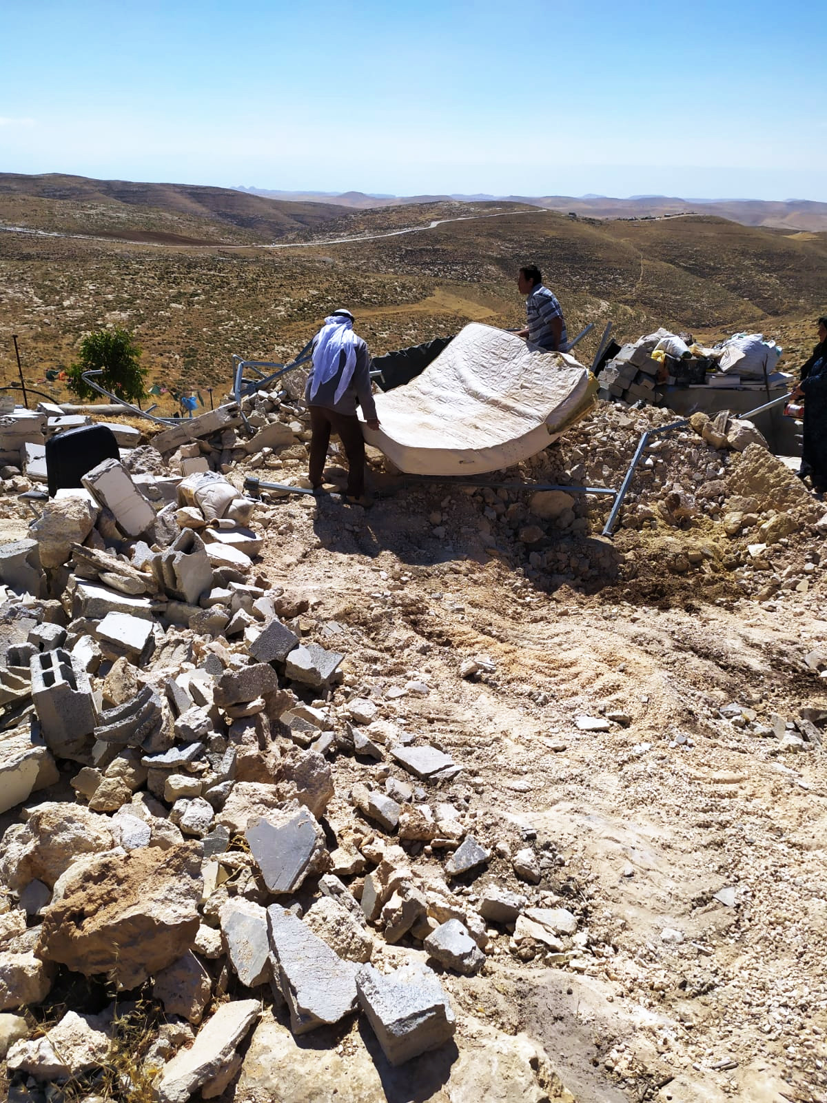
Around 75 Palestinian villages, Bedouin and Semi-Bedouin communities with roughly 118000 inhabitants are located in the areas to be annexed according to the Trump plan. These people are already been suffering annexation measures and are forcefully having to prepare for de jure annexation. This includes the ban on construction and the non-recognition of entire communities, that has resulted over the last 10 years in 4906 structures being demolished by Israel (displacing 6921 people) in Area C, and 1226 demolitions (displacing 2003 people); measures of isolation and a permit system to access and reside on the land; and denial of access to natural resources.
-
The future status of Palestinians living in these areas remains unclear. The Israeli government insists they will neither be given Israeli citizenship nor a ‘permanent residency’ status,as given to Palestinians in East Jerusalem, and therefore Palestiniansliving in these areas will remain under full Israeli security control. Israeli settler colonial apartheid will continue to treat Palestinians as non-citizens, while treating illegal Israeli settlers as citizens in an area over which Israel has expanded full legal control.
Social, economic and cultural destruction
The prevention of social, economic and cultural development is another element of the international crime of apartheid, reinforced by the annexation policies and plans.
-
Denial of access to water: Major water resources are situated in the areas that would be annexed according to the Trump plan. 60% of the West Bank’s water resources are located in the Jordan Valley and 90% of its spring water is located in the Jordan Valley. Today Palestinians have to buy 80% of the water they consume from Israel’s national water company, Mekorot at high prices. The de jure annexation would entrench this dependency.
-
The annexation of all of the Dead Sea would allow Israel to further exploit the minerals from the sea, leading to more resource extraction and environmental destruction.
-
Destruction of agriculture: Almost 50 thousand hectares of arable land are in the areas to be annexed. The lack of access to water would not allow the cultivation of lands, even in the remaining areas. Almost all the land for animal husbandry (Jordan Valley, east of Jerusalem, south of Hebron) will be annexed.
-
Fragmentation through Jewish-only roads, settlements, the apartheid Wall and the Green Line gives Israel absolute control over the movement of goods and people.
-
The destruction of farming, animal husbandry predominantly carried out by Bedouin communities and the impossibility of trade will further damage Palestinian social, economic and cultural structures.
- Israel would be the ultimate beneficiary of the destruction of the Palestinian economy in the West Bank as Palestinians would be completely dependent on its economy.
Compensation areas
-
The concept of ‘land swaps’ under occupation infringes international law, among other laws because they imply the recognition of the illegal settlements,which the international community has a duty to refrain from.
-
The areas south of the Hebron district and those close to Gaza are desert areas. The ‘Southern Triangle’ area in the Galilee (KafrQara’ villages, Baqa al-Gharbiya, Ar`rah, Umm al-Fahm , Al-Tibbiya, Al-Tirah, Qalansuwa, Kafr Bara, KafrQasim, Jaljuliya), with a population of approximately 260 000 Palestinian citizens of Israel is supposed to be part of the ‘Palestinian State’. Seven decades of dispossession have deprived these villages of most of their land, and their transfer to the Bantustans essentially follows the racialized demographic logic of Israel – to control as much land as possible with as few Palestinians as possible.